The Mount Putauaki hike is a strenuous 3-4 hour return climb to the summit of a dormant volcanic cone in Kawerau, New Zealand. Access is restricted and requires a mandatory permit and gate key obtained from Māori Investments Limited. The track offers steep gradients, native bush, and 360-degree views of the Bay of Plenty.
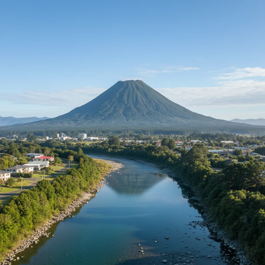
Mount Putauaki, formerly known as Mount Edgecumbe, stands as the majestic guardian of the Eastern Bay of Plenty. Rising 852 meters above sea level, this dormant volcanic cone is not merely a geological feature; it is a site of immense cultural significance to the local Māori iwi, specifically Ngāti Awa and Tuwharetoa. For hikers and outdoor enthusiasts, conquering Putauaki is a rite of passage when visiting the Whakatāne and Kawerau districts.
Unlike many public conservation lands in New Zealand, Mount Putauaki is privately owned Māori land. This distinction is critical for any visitor to understand. The mountain is not an open park; it is a taonga (treasure) that requires permission to enter. This guide serves as your comprehensive manual for navigating the logistics of permits, understanding the physical demands of the trail, and maximizing your experience in the heart of the Bay of Plenty.
Adopting a “Kawerau Base Camp” strategy is the most effective way to tackle this hike. By basing yourself in the town of Kawerau, you gain immediate access to the permit office and the trail head, allowing for an early start to beat the afternoon heat often found on the exposed volcanic slopes.
The Legend of Putauaki: More Than a Mountain
To hike Mount Putauaki without understanding its history is to miss the spirit of the journey. According to Māori legend, Putauaki was once a mountain located near Mount Tarawera. He was one of the many mountains that fought for the love of Pīhanga, the beautiful mountain standing near Lake Taupō. After losing the battle for her affection to Tongariro, a heartbroken Putauaki decided to leave the central plateau.
He began his journey north towards the ocean, guided by the spirits. However, the sun rose before he could reach the sea, freezing him in his current location near the Tarawera River. It is said that he stands there today, forever looking back towards his lost love in the south or gazing out toward the ocean he never reached. This personification of the landscape commands respect. Hikers are guests on this ancestral figure, and adhering to the rules of access is a way of showing that respect.
How to Obtain Access Permits?
The most critical aspect of planning a Mount Putauaki hike is securing the necessary documentation. You cannot simply drive to the base and start walking. The access road is gated, and the land is privately managed.
Where do I get a permit?
Permits are issued by Māori Investments Limited (MIL). Their office is located in Kawerau. You must visit the office in person to sign the indemnity forms and collect the gate key.
- Location: Waterhouse Street Extension, Kawerau.
- Opening Hours: Typically Monday to Friday, 8:30 AM to 4:30 PM.
- Weekend Access: If you plan to hike on a Saturday or Sunday, you must collect your permit and key before the office closes on Friday. The office is generally closed on weekends.
What is the cost?
As of the latest updates, there is a nominal administrative fee for the permit and a refundable bond for the key. The bond ensures the safe return of the key, which unlocks the forestry gate leading to the start of the track. Always carry cash, although EFTPOS may be available, systems can be down in regional areas.
The “No Permit” Risk
Attempting to hike without a permit is trespassing. The mountain is frequently patrolled by kaitiaki (guardians) and forestry security. Unauthorized vehicles may be towed, and trespassers can be prosecuted. Furthermore, the forestry roads leading to the start are active working environments; the permit process ensures you are aware of any logging operations that might pose a safety risk.

Trail Difficulty and Duration
Is Mount Putauaki hard to climb? The short answer is yes. While it is accessible to fit individuals, it is not a casual stroll. The gradient is relentless, and the terrain changes significantly from base to summit.
Technical Specifications
- Elevation: 852 meters (approx. 2,795 feet).
- Vertical Gain: Approximately 700 meters from the car park.
- Distance: Roughly 3-4 km one way (depending on the exact starting point allowed by forestry operations).
- Duration: Allow 3 to 4 hours for a return trip. Fast hikers may summit in 60-90 minutes, but the descent requires care.
- Difficulty Rating: Hard / Strenuous.
The track is technically a 4WD access road for the radio transmitter at the summit, but calling it a “road” can be misleading. It is steep, often loose with scree, and exposed to the elements. There is also a more direct walking track that cuts through the bush, which is shorter but significantly steeper, often requiring hikers to use tree roots for leverage.
Step-by-Step Hiking Guide
Phase 1: The Forestry Approach
Once you have unlocked the gate with your key, you will drive up a gravel forestry road to the designated parking area. The drive itself takes you through commercial pine forests. Park your vehicle securely. Do not block any skid sites or road access, as logging trucks operate frequently.
Phase 2: The Lower Slopes
The hike begins on a well-formed but steep gravel track. In the summer months, this section can be incredibly host as it is sheltered from the wind but exposed to the sun. You will be surrounded by regenerating native bush and pine. The incline is consistent—there are very few flat sections to recover, so pacing yourself here is vital.
Phase 3: The Main Ascent
As you gain altitude, the vegetation transitions into more established native forest. You may have the option to take the “shortcut” track. This narrow path cuts straight up the face of the mountain, bypassing the switchbacks of the road. While it saves distance, it burns energy. It is recommended to take the road up to save your legs and perhaps take the track down if you are confident in your footing.
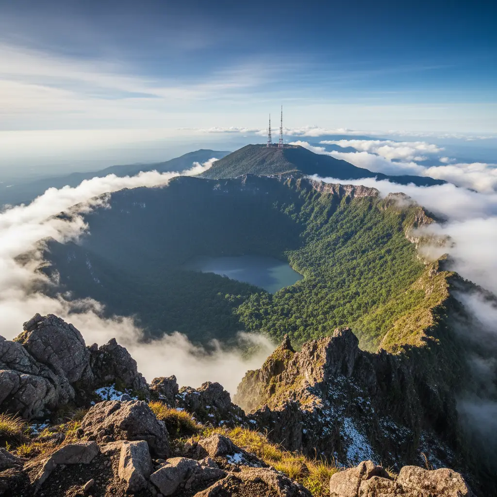
You will eventually reach a plateau area near the transmitter station. This is a false summit. Do not stop here; the true magic lies at the crater rim.
Phase 4: The Crater Rim
The final push takes you to the fire lookout and the radio tower. From here, you can walk around the crater rim. The crater itself is a lush, green amphitheater, now reclaimed by nature, housing a small catchment of water and dense vegetation. It is a stark contrast to the rocky exterior of the cone.
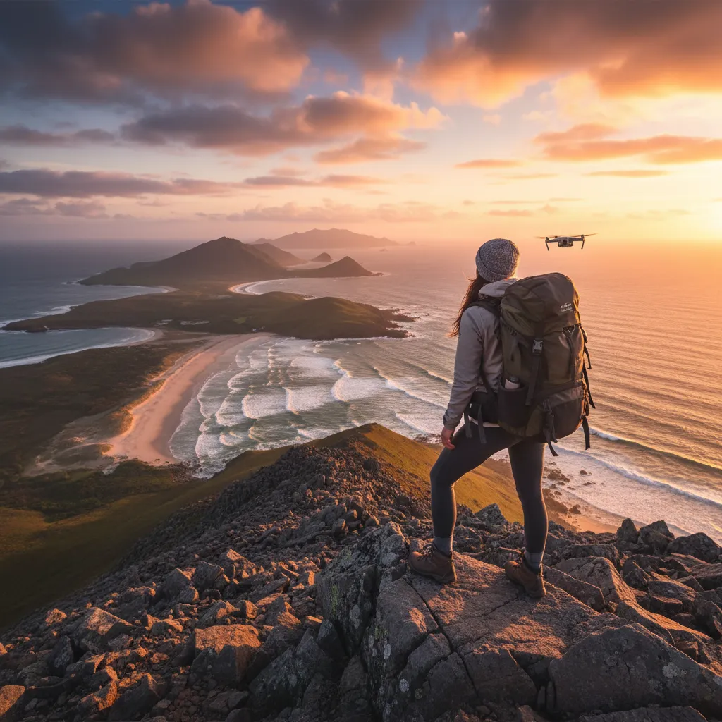
Summit Views and Photography Tips
The reward for the grueling uphill slog is one of the finest panoramic views in the North Island. On a clear day, the visibility is astounding.
What can you see?
- North: The expanse of the Bay of Plenty coastline, Whale Island (Moutohorā), and the active volcano White Island (Whakaari) puffing steam on the horizon.
- South: The imposing Mount Tarawera, scene of the devastating 1886 eruption, and further afield, the snowy peaks of Tongariro and Ruapehu in the Central Plateau.
- East/West: The vast Kaingaroa Forest and the rolling farmland of the Rangitaiki Plains.
Photography Strategy
For the best photography results, aim to summit in the morning. The morning light illuminates the coastline and White Island beautifully. If you are shooting the crater, a wide-angle lens (16mm-24mm) is essential to capture the scale of the depression. A polarizing filter will help cut through the atmospheric haze often found in the Bay of Plenty, making the blues of the ocean and the greens of the forest pop.
Essential Gear for the Climb
This is an alpine environment, even if it is near the coast. Weather conditions can change rapidly.
- Footwear: Sturdy hiking boots with ankle support are highly recommended. The gravel road can be slippery on the descent, and the bush track is full of roots. Trail runners are acceptable for experienced hikers, but casual sneakers are discouraged.
- Water: There is no water source on the mountain. You must carry at least 1.5 to 2 liters per person. The climb is sweaty work, and dehydration is a common issue.
- Clothing: Layering is key. You will be hot on the ascent but cool quickly at the windy summit. Bring a windbreaker or a light rain jacket.
- Sun Protection: High SPF sunscreen, sunglasses, and a hat are non-negotiable. The UV index in New Zealand is extreme.
- Communication: Cell phone reception is generally good due to the transmitter at the top, but always tell someone your plans before you go.
The Kawerau Base Camp Strategy
Smart travelers treat Kawerau not just as a pitstop, but as a strategic base camp. After the hike, your muscles will be fatigued. Driving long distances immediately afterwards is uncomfortable.
Post-Hike Recovery
Kawerau is famous for its geothermal activity. The Maurie Kjar Memorial Swimming Pool complex offers free access to thermal pools (though check current pricing for private areas). Soaking in the geothermal waters is the perfect way to reduce lactic acid buildup in your legs after the Putauaki climb.
Additionally, staying in Kawerau allows you to explore the Tarawera River walks or visit the Tarawera Falls the following day, creating a robust weekend itinerary of outdoor adventure centered around this industrial yet scenic town.
Frequently Asked Questions
How long does it take to hike Mount Putauaki?
Most hikers complete the return trip in 3 to 4 hours. This allows for a 2-hour ascent, time at the summit for photos and rest, and a 1-hour descent. Extremely fit trail runners may complete it in under 2 hours.
Can I hike Mount Putauaki on the weekend?
Yes, but you must plan ahead. The permit office (Māori Investments Limited) is closed on weekends. You must collect your permit and key on Friday during business hours to access the mountain on Saturday or Sunday.
Is the Mount Putauaki track suitable for children?
The track is suitable for older children and teenagers who have a moderate level of fitness. It is generally considered too steep and long for young children (under 7) unless they are experienced hikers. It is not stroller accessible.
Are dogs allowed on Mount Putauaki?
Generally, dogs are not allowed. This is working farm and forestry land with potential kiwi zones nearby. Always check the specific conditions on your permit from Māori Investments Limited, as rules regarding animals can change.
What is the height of Mount Putauaki?
Mount Putauaki stands at 852 meters (2,795 feet) above sea level. It is the most prominent landmark in the Eastern Bay of Plenty.
Is the track safe when it is raining?
Hiking during heavy rain is not recommended. The clay and pumice soil can become extremely slippery, and the 4WD track becomes slick. Visibility at the summit will also be zero, negating the reward for the climb.