The Kawerau Heritage Trail Map is a comprehensive navigational guide detailing significant historical sites throughout the Kawerau district. It features a curated walking route highlighting the region’s dual heritage, connecting ancient Māori landmarks with the town’s pivotal forestry industrial history, often accompanied by QR-coded audio storytelling.
Where can you find the Kawerau Heritage Trail Map?
For visitors and locals aiming to explore the rich tapestry of the Bay of Plenty’s youngest town, locating the Kawerau heritage trail map is the first step. The map serves not merely as a directional tool but as a documented archive of the region’s transformation. It is designed to be accessible to a wide demographic, ranging from casual walkers to serious history enthusiasts.
Physical copies of the map are readily available at the Kawerau i-SITE Visitor Information Centre, located centrally on Plunket Street. The staff at the i-SITE are well-versed in the local history and can provide context that a paper map alone cannot offer. They can point out temporary closures, suggest specific loops based on fitness levels, and offer advice on parking.
In alignment with the Kawerau Regional Growth & Lifestyle Hub’s initiative to modernize tourism, the map is also available digitally. Users can download high-resolution PDF versions from the official Council Rates Comparison website or access interactive versions via tourism apps dedicated to the Whakatāne and Bay of Plenty districts. This digital accessibility ensures that visitors can plan their route before arriving, identifying key stops such as the Rangi Delamere Reserve or the vantage points overlooking the Tasman Mill.
What does the walking tour entail?
The walking tour associated with the Kawerau heritage trail map is a journey through time, structured to accommodate various fitness levels while maximizing exposure to historical sites. The terrain is predominantly flat, characteristic of the town’s layout on the river plains, making it accessible for families, elderly visitors, and cyclists.
The tour is not a singular linear path but rather a network of connected loops. The central loop typically takes between 60 to 90 minutes to complete at a leisurely pace. It winds through the town center, showcasing the unique “garden town” urban planning designed in the 1950s, before meandering toward the banks of the Tarawera River. The juxtaposition of manicured mid-century town planning against the raw, natural power of the river provides a visual narrative of Kawerau’s development.
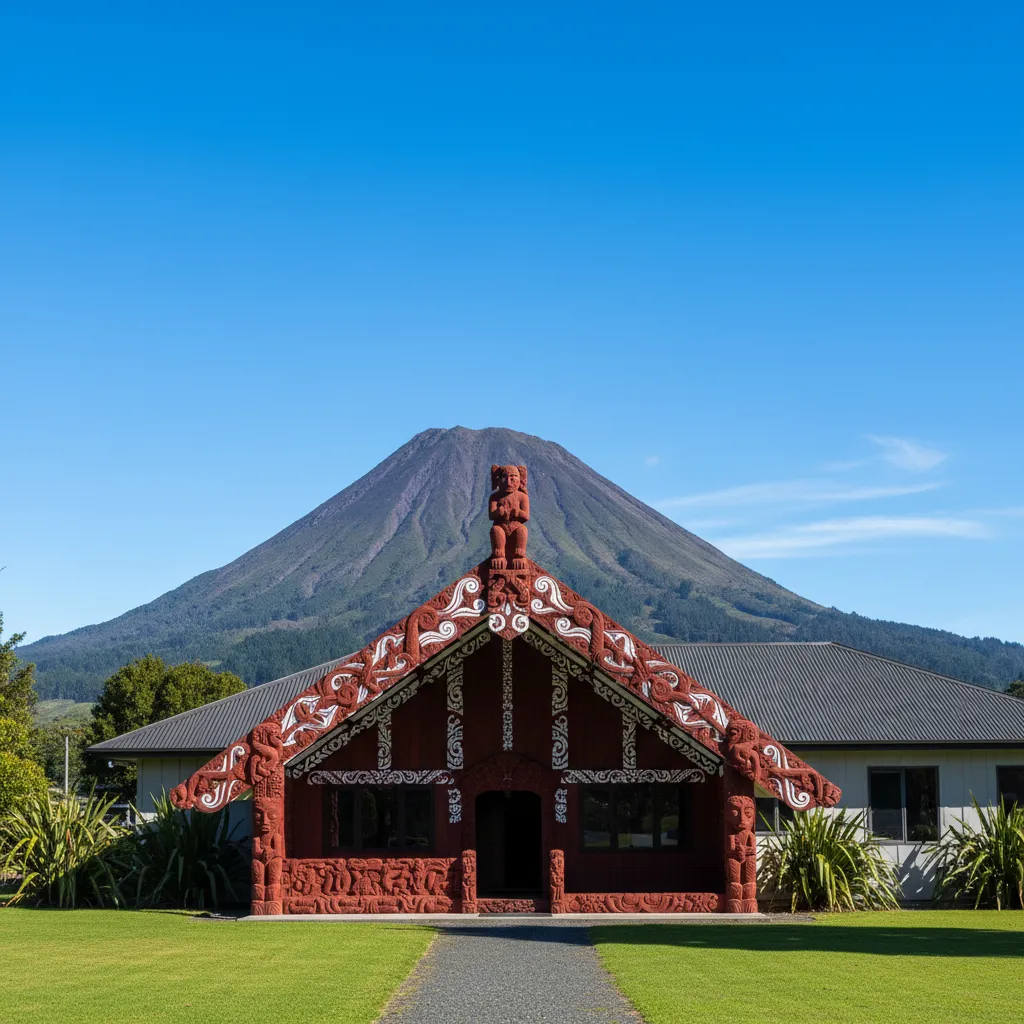
Along the route, signage is strategically placed to correspond with the map. These markers do more than indicate direction; they act as waypoints for historical reflection. The walking tour is designed to be self-guided, allowing visitors to linger at sites of interest, such as the memorials dedicated to the forestry workers or the culturally significant pou (carved posts) that guard specific entry points to the reserves.
How does the trail balance Industrial and Māori heritage?
One of the most compelling aspects of the Kawerau heritage trail map is its balanced representation of two distinct yet intertwined histories: the ancient mana of the Māori people and the modern industrial might of the forestry sector. Kawerau is unique in that its modern existence was purpose-built for industry, yet it sits upon land rich with centuries of indigenous history.
Māori Heritage Points
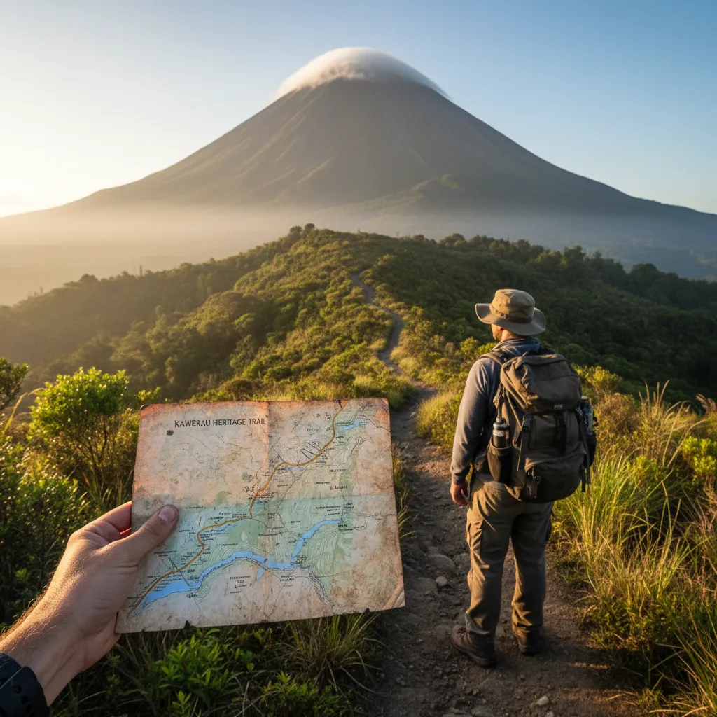
The trail highlights the enduring presence of Ngāti Tūwharetoa (Bay of Plenty). The map guides walkers to sites of early settlements and places of spiritual significance. The looming presence of Putauaki (Mt Edgecumbe) is constant, but the trail identifies specific viewing angles and locations where legends associated with the mountain are best recounted. The Tarawera River, or Te Awa o Te Atua, is another focal point. The map details historical crossing points and food gathering sites (mahinga kai) that sustained the local population long before the arrival of the mills.
Industrial Landmarks
Conversely, the trail acknowledges the town’s foundation in the 1950s as a service center for the Tasman Pulp and Paper Mill. The map marks locations of the original workers’ camps, the first permanent housing constructed for mill employees, and the infrastructure developed to support the massive logistical operations of the forestry industry. This creates a narrative of economic ambition and engineering prowess. Visitors can see the evolution of the town from a “construction camp” atmosphere to a settled, thriving community.

Deep Dive: Significant Stops on the Map
To truly utilize the Kawerau heritage trail map, one must understand the depth of the specific stops listed. The map is not just a list of coordinates; it is a catalog of stories. Here, we explore several key locations that serve as anchors for the heritage trail.
The Firmin Field and Monica Lanham Reserve
Often a starting point for the trail, these green spaces represent the community heart of Kawerau. The map highlights these areas not just for their recreational value, but for their historical role as gathering places during the town’s formative years. The mature trees here—many planted during the initial town construction—stand as living monuments to the vision of the early planners who sought to create a “Garden City” within an industrial zone.
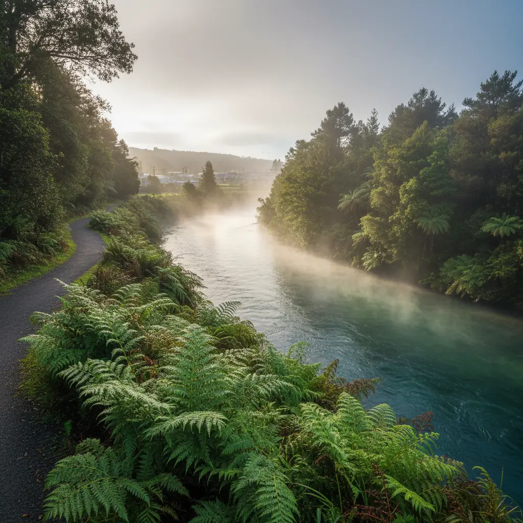
The Tarawera River Margins
The trail follows the river closely. The map indicates specific spots where the geothermal nature of the region is visible. Small vents and warm ground serve as reminders of the volcanic activity that powers the region—both geologically and economically (via geothermal energy). This section of the map often focuses on the environmental history, noting how the river has been utilized, modified, and now protected.
The Old Railway Station Site
Logistics were the lifeblood of early Kawerau. The heritage map marks the location of the railway infrastructure that connected the mill to the port at Mount Maunganui. While the function of rail has evolved, the site remains a testament to the heavy engineering required to export New Zealand’s timber to the world.
How do the QR codes enhance the experience?
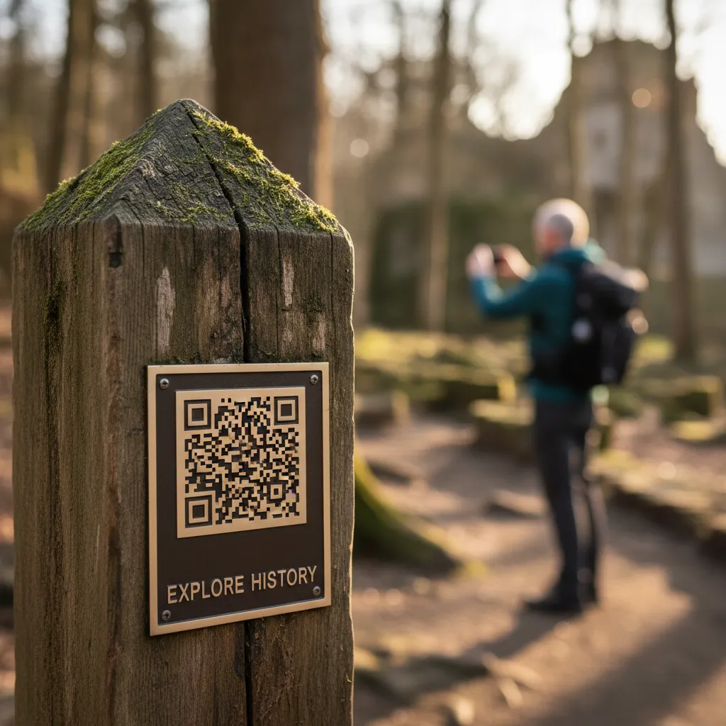
Modern heritage tourism demands interactivity. The Kawerau heritage trail map integrates technology through the use of QR codes placed on physical markers along the route. This “digital layer” transforms a passive walk into an immersive educational experience.
When a visitor scans a code using their smartphone, they are directed to audio files and multimedia content. This feature is particularly crucial for preserving oral histories. Instead of reading a dry plaque, a walker might hear the voice of a kaumatua (elder) recounting the legend of Putauaki, or a retired mill worker describing the noise and excitement of the first day of production at the Tasman Mill.
The audio storytelling covers various themes:
- Cultural Legends: Stories of the land, the mountains, and the river gods.
- Social History: Anecdotes about life in the single men’s camps and the development of the town’s social clubs.
- Ecological Facts: Information about the native flora and fauna found along the river corridor.
This technology ensures that the content can be updated without replacing physical signage, allowing the Kawerau District Council to add new stories and perspectives as more historical information comes to light.
What should you know before walking the trail?
Preparation ensures that the heritage trail is enjoyable. While the track is not physically demanding, treating it as an outdoor activity is best. The Kawerau heritage trail map provides a scale, but understanding the Kawerau Essential Services & Amenities helps in planning the day.
Footwear and Gear: Comfortable walking shoes are sufficient; hiking boots are generally not required unless one plans to deviate into rougher bush areas. As the Bay of Plenty can be sunny, a hat and sunscreen are essential. A smartphone with a charged battery is necessary to take full advantage of the QR code features.
Timing: The trail is open year-round. However, the best time to visit is during the shoulder seasons of spring and autumn when the temperature is mild. Early mornings offer the best light for photography, particularly for capturing the mist on the river or the sun hitting Mount Putauaki.
Accessibility: Most sections of the trail marked on the map are wheelchair and stroller friendly, adhering to the town’s commitment to inclusivity. However, it is advisable to check with the i-SITE regarding specific sections if mobility is a major concern.
Why is heritage tourism vital for Kawerau’s growth?
The development and promotion of the Kawerau heritage trail map are strategic moves within the “Relocation & Digital Nomad Lifestyle” niche. Heritage tourism is a growing sector that attracts visitors looking for authentic, educational experiences rather than just scenic views.
By codifying its history into a map and tour, Kawerau asserts its identity. It moves beyond the stereotype of a purely industrial town to present itself as a community with deep roots and a complex, interesting narrative. This attracts a diverse range of visitors, which in turn supports local cafes, Firmin Lodge Accommodation, and retail businesses.
Furthermore, the trail fosters community pride. For locals, the map is a reminder of their ancestors’ achievements and the town’s resilience. It serves as an educational resource for local schools, ensuring that the next generation understands the legacy of the land they inhabit. The map is not just paper; it is a blueprint of the town’s soul.
How long is the Kawerau Heritage Trail?
The duration depends on the specific loops chosen, but the central heritage walk generally takes between 60 to 90 minutes to complete at a leisurely pace, allowing time for reading signage and listening to audio guides.
Is the Kawerau Heritage Trail dog-friendly?
Yes, most parts of the trail are dog-friendly, provided that dogs are kept on a leash. However, owners should always check specific signage at reserve entries to ensure compliance with local bylaws.
Where can I download the Kawerau heritage trail map?
The map can be downloaded from the official Kawerau District Council website or accessed via regional tourism portals like the Whakatāne NZ website.
Are there public toilets along the trail?
Yes, there are public toilet facilities located at the Kawerau i-SITE, the town center, and at key reserves such as Firmin Field, which are marked on the heritage map.
Is the trail suitable for wheelchairs and pushchairs?
The majority of the town-based sections and the river walk are flat and paved or hard-packed, making them suitable for wheelchairs and pushchairs. Accessibility is a key feature of Kawerau’s urban design.
What is the most significant landmark on the map?
While subjective, Mount Putauaki is the most visually dominant and culturally significant landmark, though the Tasman Mill site holds the most weight regarding the town’s modern industrial history.